History 
Local historians claim that the word davao came from the phonetic blending of the word of three Bagobo subgroups when referring to Davao River, an essential waterway which empties itself into Davao Gulf near the city. The aboriginal Obos who inhabit the hinterlands of the region called the river, Davoh; the Clatta or Guiangans called it Duhwow, or Davau, and the Tagabawa Bagobos, Dabu. To the Obos, the word davoh also means a place "beyond the high grounds", alluding to the settlements located at the mouth of Davao River which were surrounded by high rolling hills. When asked where they were going, the usual reply is davoh, while pointing towards the direction of the town. Duhwow also refers to a trading settlement where they barter their forest goods in exchange for salt or other commodities. Spanish influence was hardly felt in the Davao until 1848, when an expedition led by Don Jose Uyanguren came to establish a Christian settlement in an area of mangrove swamps that is now Bolton Riverside. Davao was then ruled by a Muslim chieftain, Datu Bago, who held his settlement at the banks of Davao River (once called Tagloc River by the Bagobos). After Uyanguren defeated Datu Bago, he renamed the region Nueva Guipúzcoa, in honor of his home in Spain, and became its first governor. Uyanguren's efforts to develop the area, however, did not prosper. A few years after the American forces landed in 1900, private farm ownership grew and transportation and communication facilities were improved, thus paving the way for the region's economic growth. A Japanese entrepreneur named Kichisaburo Ohta was granted permission to exploit vast territories which he transformed into abacá and coconut plantations. The first wave of Japanese plantation workers came onto its shores in 1903, creating a Little Japan. They had their own school, newspapers, an embassy, and even a Shinto Shrine. On the whole, they established extensive abaca plantations around the shores of Davao Gulf and developed large-scale commercial interests such as copra, timber, fishing and import-export trading. Filipinos learned the techniques of improved cultivation from the Japanese so that ultimately, agriculture became the lifeblood of the province's economic prosperity. Davao was formally inaugurated as a chartered city on March 1, 1937 by President Manuel L. Quezon. Thirty years later, Davao was subdivided into three independent provinces, namely Davao del Norte, Davao del Sur, and Davao Oriental. Over the years, Davao has become an ethnic melting pot as it continues to draw migrants from all over the country, lured by the prospects of striking it rich in the country's third largest city. On December 8, 1941 Japanese planes bombed the city. Japanese occupation started in 1942. In 1945, American and the Philippine Commonwealth forces liberated Davao City from Japanese forces. [edit] Culture and Heritage
. Easy assimilation is an integral essence of multi-cultural Davao. Being a chartered city, it has grown appreciating differences in culture and tradition by numerous ethnic groups that integrated easily to the local tribes already present during its infancy as a city. Like most cities in the country, Catholics largely populate Davao. Christian churches and chapels dot the city's landscape along with some temples, mosques, and other places of worship. Another Spanish influence that remains up to this day is the observance and celebration of barrios (or villages) of the day of their respective patron saint called "Fiesta". It is in these celebrations wherein songs, dances and other forms of arts and merrymaking from various cultures have evolved creatively into the sights and sounds of Davao now. Such showcases point to its ultimate climax as the celebration of all celebrations - the weeklong Kadayawan sa Dabaw Festival. [edit] Geography and Physical Characteristics
The land area of Davao City is 2,443.61 square kilometers. It is divided into 3 congressional districts, which are further divided into 11 administrative districts containing a total of 184 barangays. Almost 50% of its total land area is classified as timberland or forest. Agriculture utilizes about 43%. This is reflective of the fact that agriculture is still the largest economic sector. Big plantations that produce banana, pineapple, coffee, and coconut eat up a large chunk of the total land area. [edit] LocationDavao City is approximately 588 statute miles southeast of Manila. Traveling by sea, its location from Manila and Cebu is 971 and 593 nautical miles (1,098 km) respectively. It is the capital of the Mindanao and is the biggest urban market in the growth polygon called BIMP-EAGA (Brunei-Indonesia-Malaysia-Philippines East Asian Growth Area) Presently, built-up areas used for residential, institutional, commercial, and industrial purposes represent about 10% of the total land area. Under the approved land use plan built-up and settlement area will cover 15% of the total area while agricultural will be maximized with 67.19%. The remaining 17.68 will be devoted to forestry and conservation. [edit] ClimateDavao City is typhoon-free. The city enjoys a weather that remains balmy all year round. It is characterized by a uniform distribution of rainfall, temperature, humidity, and air pressure. It has no pronounced wet or dry season. Weather predictability makes it highly conducive to agricultural production. Temperature ranges from 20 to 32 degrees Celsius and average rainfall is up to 2,000 mm yearly. [edit] LanguageDinabaw is the most widely spoken language in the city, while Tagalog comes a distant second. Bisaloglish, an informal mixing of the above languages, is spoken as well. English is the medium of instruction in schools and is widely understood and spoken especially in the business community and also for all official documents. [edit] ReligionThe most dominant group is the Roman Catholic at 83.83%, other Christian groups comprise 15% and the remaining 1.17% belongs to other non-Christian faiths (Islam) [edit] Accessibility
. Davao City is very accessible and is the gateway to the Brunei-Indonesia-Malaysia-Philippines East Asia Growth Area or BIMP-EAGA. [edit] By landLike most of the cities in the Philippines, there is an abundance of buses, jeepneys, taxicabs and tricycle which makes getting around the city quite easier. There are also bus terminals at Davao City, like the Davao City Ecoland Transport Bus Terminal. Lawin, Monoy jeepneys and even L300 and Van-like jeepneys together with Multicabs are roaming around the city. Airconditioned and Non-Aircon taxis are also abundant in the city. You can easily call taxis a there dispatching areas or simply flaging your hand in the streets. Like the other places in the Philippines tricycles, a 3-wheeled vehicle, powered by a motorcycle with a seating capacity of 3-7 passengers, depending on size. [edit] By seaThe city is also served by passenger ferries throughout the Philippines at Sasa Wharf and Sta. Ana Wharf.
[edit] By airDavao City is served by Francisco Bangoy International Airport (Davao International Airport). DIA is currently served by the following carriers:
[edit] Economy
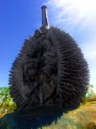
Davao City is the "Crown Jewel" of Mindanao in terms of economic activity. It is the most important economy in the island, being the third biggest city in terms of area in the country. Like the rest of the country, Davao City operates on an economic system that is market-oriented, although pricing mechanisms remain regulated in a few sectors (particularly on basic commodities) to protect consumers. The competitiveness of the market has been enhanced through the dismantling of protection for "infant industries" and the breakdown of industries with monopolistic or cartel tendencies. On the international front, the economy has been opened up to global competition, through a tariff reduction program and the loosening of restrictions on inward foreign investment. The result is a diverse economy, featuring a sound mix between the agricultural (roughly 45%), industrial (15%) and service (at around 35%) industries. Poverty reduction has become the main goal of the local government which is being addressed through programs and projects one of which is the encouragement of inward investments to industries that are labor-intensive. Fortunately for Davao, private investments has Davao City's economy is steadily growing in the last two decades. The City has shifted counting investments from millions in the 80s to billions in the 90s and up to the present millennium. Among Asian cities, and apart from Cebu and Manila, Davao has maintained its competitive position in attracting investments and in penetrating new foreign markets owing to its resilient exports base, peaceful business climate, better quality of life, and rich pool of skilled workforce. With over 1.2-Million people as primary market base, the city is conducive to business as evidenced by the presence of the country's top 200 companies. Inflow of investments has been remarkable in the last ten years. Export in the City is now billion dollar industry with a growing niche market for its products. The stable banana and flourishing pineapple industries are among the country's leading export commodities. A net exporter since 1987, Davao City largely contributed in making the Philippines as the world's top 3 banana exporter. Primarily an agricultural area, almost all kinds of fruits thrive in Davao including the exotic Durian. Other major agriculture-based exports are pomelo, mango, coconut, papaya, mangoosten, and even flowers. The productive linkages between established businesses and Davao City community reinforced the competitive quality of life in a city that has consistently maintained single digit inflation rate since 1993. Along with flourishing investments and exports, the low inflation rate serve as concrete illustration of the remarkable gains from Davao City's sustained competitiveness nurtured by high level of responsiveness of the local government which put priority focus in facilitating business-friendly initiatives and in ensuring a peaceful and prosperous environment. [edit] GovernmentUnique to the local government set-up of the city is the designation of a deputy mayor by the city mayor. Although an appointed official only, the deputy mayor serves as a direct link to the city mayor, especially for people living outside the city proper. The deputy mayor also serves as the city mayor's representative in community events. The functions of the position are considered complementary to the functions of the city vice-mayor, given the large territorial jurisdiction of the city. The city is politically subdivided into 184 barangays. The current mayor of Davao City is Rodrigo Duterte, a former government prosecutor and congressman. He is assisted by city vice-mayor Sara Duterte, his daughter. Davao City comprises 184 barangays with three legislative districts. The City Government of Davao is now proposing to add two more Congressional Districts. [edit] 1st District[edit] PoblacionNo. of Barangays: 40 Population (2007): 153,005
[edit] TalomoNo. of Barangays: 14 Population (2007): 360,010
[edit] 2nd District[edit] AgdaoNo. of Barangays: 11 Population (2007): 98,586
[edit] BuhanginNo. of Barangays: 13 Population (2007): 232,865
a. ^ Created into separate barangays under Sangguniang Panlungsod Ordinance No. 16103, ratified on July 25, 2004; taken from Barangay Pampanga.[1] [edit] BunawanNo. of Barangays: 9 Population (2007): 123,767
[edit] PaquibatoNo. of Barangays: 13 Population (2007): 38,266
[edit] 3rd District[edit] BaguioNo. of Barangays: 8 Population (2007): 27,255
[edit] CalinanNo. of Barangays: 19 Population (2007): 76,024
[edit] MarilogNo. of Barangays: 12 Population (2007): 42,718
[edit] TugbokNo. of Barangays: 18 Population (2007): 83,863
[edit] TorilNo. of Barangays: 25 Population (2007): 126,978
[edit] Security and Civil DefenseThe city government has invested millions of pesos to ensure the security of people living and working in Davao City. Aside from the usual forces of the Philippine National Police, a special military task force has been formed to insulate the city from terrorist attacks and other forms of criminality. The Task Force Davao, as it is named, is affiliated with the Philippine Army and is headed by an army colonel. The city government also maintains a 24-hour emergency response system patterned after the 9-1-1 systems in Canada and the United States. People can dial the 911 number to report emergencies and criminal incidents. A curfew on minors is also observed in the city. All business establishments, in particular bars and discos, are mandated by a city ordinance to refrain from selling alcoholic drinks beyond 2:00 am. Also, motorcycle drivers with no helmets and motorists with defective lights are not allowed to enter or drive in the city. Regular checkpoints in key parts of Davao City and at the city boundaries are conducted 24 hours to ensure the strict implementation of traffic rules. The use of fireworks and other similar pyrotechnics, as well as smoking, is strictly prohibited in most of the city. Even outdoors, if you are under a roof of any kind, you are prohibited from smoking. Violators are made to pay hefty fines, perform community service, serve jail time, or a combination of the three. Littering is also prohibited. [edit] Foreign RelationsThe influx of foreign visitors and the presence of expatriates and migrants in the city have prompted the governments of Japan, Malaysia, Indonesia and the United States to open consular offices in the city. The US Embassy in the Philippines opened a virtual consulate where inquiries regarding visa issuances, foreign relations concerns and travel to the United States can be made on the Internet by e-mail and chat. The virtual consulate website [1] is maintained in coordination with Ateneo de Davao University, Holy Cross of Davao College and AMA Computer College. [edit] Physical InfrastructureThe presence of basic infrastructure within the city such as airport, seaports, roads, bridges, telecommunications, condominiums, malls and first class hotels has sustained the economic growth in the last 10 years. Due to the city's unprecedented growth, a clamor for higher capacity infrastructures resulted to a number of modernization projects now ongoing to meet the demands of the new millennium. [edit] Hotels and Inns
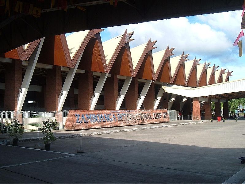
[edit] Airport
The Francisco Bangoy International Airport (Davao International Airport) is the busiest airport in Mindanao. Expansion and modernization began in 1998. Today, the new DIA (opened in December 2003) has begun accommodating larger jets such as the Boeing 747, the Airbus A330 and the Airbus A340. [edit] Roads and BridgesConstruction of more roads and bridges are also underway. The construction of the City's third major road - the Buhangin underpass was completed in the 1st quarter of 2003. A Traffic Management and Computerization Scheme was also implemented. The traffic lights in the city is considered as the most modern in Asia.[3] Davao City is ranked no. 5 among cities in Asia with better traffic flow based on vehicles per kilometer of city road. [edit] SeaportsThe Port of Davao has 2 government seaports Sasa International Wharf and Sta. Ana Domestic Wharf and 9 privately owned ports. In addition, the Toril International Fish Port Complex accommodates small and large-scale fishing activities as well as provide among others cold-storage facilities. [edit] TelecommunicationsCommunication links within the key business areas are adequate. With the deregulation and privatization policies of the Philippine government, the number of telecommunications player is projected to increase as well as offer affordable telecommunications services to subscribers/clienteles. Leading telecommunicatons companies put facilities in Davao City paving clear connections from and to various destinations in the Philippines and all over the world. The Philippine Long Distance Telephone Company (PLDT), Bayan Telecommunications Corporation (Bayantel), Globe Telecom, Smart Communications and Sun Cellular operate vital transmission towers in the city. [edit] Internet Service ProvidersThere are 6 Internet Service Providers operating in Davao City offering dial-up, dedicated and DSL types of service. The City has over a hundred Internet cafés operating in strategic areas where one can surf, chat, play games, send and view e-mails, and engage in e-commerce using the latest computer innovation and technology.And soon new service provider Sulubit. [edit] Future DevelopmentsIn recent years, Davao City maintain its competitiveness and now attracts big business and investments. Today, negotiations and constructions are going on to put up a project here in the city. The Ayala Land and Anflocor made a venture to build Abreeza, a P3.5 billion mall. It will have a 3-storey shopping mall and 2 Business Process Outsourcing (BPO) and a future hotel, residential and commercial lots.[4] On the other hand, Four BPOs eye Davao for expansion. Four business process outsourcing (BPO) companies have trained their sights on this city for their expansion programs. The companies are the Canada-based Infotech Outsourcing Services, Mustang Technologies, Antech Solutions, and GenTech Software, according to Lizabel Holganza, president of ICT Inc. [5] More projects are planned in the city. The Davao-Samal Bridge, which will start its construction on 2017. The concept of this bridge will be like the San Francisco's Golden Gate Bridge, connecting Davao City and Island Garden City of Samal[6]. Other projects also put into consideration are the Davao Light Rail Transit, the LRT system will serve the coastal builtup area of Davao City, as well as neighboring areas in Davao del Sur (Sta. Cruz), and Davao del Norte (Panabo City). The project cost was P240 billion in 1997 when it was first proposed. It is also proposed to be 60 kilometers in length and a BOT (build, operate, transfer) project. [7]. Here is the list of some propose and under construction projects in Davao City:
References:[8][9][10][11][12][13][14][15][16][17][18] [19] [20] [edit] Shopping Centers and Malls
[edit] Proposed and Under Construction Malls
Reference:[21] [edit] Tourism.jpg)
[edit] Tourists' Spots
[edit] Socio-cultural Environment[edit] Health and HospitalThe average life expectancy of Davaoeños is 70 for females and 65 for males. There are about 31 hospitals with a total of 1,963 beds in Davao City. Very affordable medical services are made available to poor residents through the Davao Medical Center, which has the most hospitals beds at 600. 
On the other hand, hospitals such as the Davao Doctors Hospital, San Pedro Hospital, Brokenshire Memorial Hospital, Ricardo Limso Medical Center, and Davao Medical Center are training hospitals that also offer specialized medical care services. Davao Regional Hospital in neighboring Tagum City, also offers the same quality specialized physician training and health services. Psychiatric hospitals, psychotherapy clinics and counselling centers are also found in the city, directed and manned by internationally-trained counselors, psychologists, psychometricians and psychiatrists. In Davao City, there are currently six large tertiary hospitals: Davao Doctors Hospital, San Pedro Hospital, Brokenshire Memorial Hospital, Davao Medical School Foundation Hospital, Ricardo Limso Medical Center, and Davao Medical Center.
[edit] EducationThe government provides free education at the primary (grade school) and secondary (high school) levels. Government scholars from all over the region enjoy free college education in state-run universities such as the University of the Philippines, Mindanao and the University of Southeastern Philippines. The literacy rate of the country is 93.9%. Davao City has a literacy rate of 91.05%. Among the most popular tertiary schools located in Davao City are Ateneo de Davao University, University of the Immaculate Conception, San Pedro College, University of Mindanao, Holy Cross of Davao College,Davao Doctors College, Brokenshire College, Philippine Women's University of Davao,St. Peter's College of Toril, Assumption College of Davao, Mindanao Kokusai Daigaku (or Mindanao International College) and others like Davao Merchant Marine Academy (DMMA), MATS College of Techonology, John Paul II College, AMA Computer College, STI College of Davao,and Rizal Memorial College. The city has contributed much to the Southern Mindanao's ever increasing pool of masters and doctorate degree holders helping the city's gain the distinction of having one of the highest numbers of Masters in Business Administration (MBA) graduates in the region. The city is considered the Center for Learning and Education in Southern Mindanao. Currently, it has 374 elementary schools, 65 secondary schools including the Philippine Science High School Southern Mindanao Campus, and 46 colleges and universities.
History OF ZAMBOANGA CITY
The early Malay settlers called the region “Jambangan”, which means Land of the Flowers. These Malays who built their settlements by the river banks were the Subanons, that is the “People of the River”. Their chief, Saragan, lived with his family atop the legendary Mount Pulumbato that today lords over Pasonanca and Climaco Freedom Park (formerly Abong-Abong Park) then later on, the Samals and the Badjaos who came on their frail vintas also settled here, building their huts along the shorelines and confused “Jambangan” with “Samboangan” which comes from the word “Sabuan”, the wooden pole used to help push their vintas in shallow waters or to tie them for anchorage purposes.[11] The Spanish colonizers found difficulty in pronouncing “Samboangan” and instead called the place “Zamboanga”. The city has rich and colorful history. It was the center of barter trading among Chinese, Malays and the native Tausugs, Samals, Subanons, and the Badjaos as early as the 13th and 14th centuries.[12] It was in 1569 when the Spaniards made their presence felt with a small Catholic Mission established briefly at La Caldera, now known as Recodo. The city's patron saint is La Nuestra Senora del Pilar de Zaragoza Our Lady of the Pillar of Zaragoza, Spain. A statue honoring the saint is prominently embossed above the façade on the eastern wall of Fort Pilar. Fort Zamboanga was founded, in 1635, by the Spanish, and was the focus of a number of battles between Moro pirates and the Spanish until 1718, when a modifications to the fort were made. [13] On June 23, 1635, the cornerstone of what is now known as Fort Pilar was laid by Father Melchor de Vera, a Jesuit Priest-Engineer and the Spanish authorities. This date marked the change of the name of the place from Samboangan to Zamboanga. It is the city’s founding date. The meter-thick walled fort is officially called El Real Fuerza de Nuestra Señora del Pilar de Zaragoza (also called El Real Fuerza de San José in its early days).[14] During the US administration of the Philippines following its acquisition by the United States as a result of the Spanish-American War in 1899, Zamboanga hosted a number of American regional governors, including General John "Black Jack" Pershing (Pershing was Military Commander/Governor of the Moro Province from 1909 to 1914). Prior to World War II, Zamboanga was the location of Pettit Barracks, where part of the US Army's 43rd Infantry Regiment was stationed. After the successful invasion of the Philippines, the Japanese occupying force landed at Zamboanga on 2 March 1942, and formed a defense headquarters in Zamboanga, which was taken by combined US and Philippine Commonwealth forces in March 10, 1945. In 1899, after the Spanish-American War in the Philippines, the United States of America defeated the forces of the revolutionary government of the Republic of Zamboanga under popular President and Gen. Vicente Alvarez y Solis thereby establishing full authority in Zamboanga. The U.S. military then appointed Alvarez's political opponent and U.S. friendly, Isidor Midel, to finish the Presidential term of Alvarez.[15] In March 1901, a municipal election was held with the help of the U.S. administration, wherein Mariano Arquiza was elected President of the new republic for two years ending in 1903. Then after, the Moro Province was established in Mindanao and Sulu, and the original ancient Zamboanga was made its capital. The first U.S. form of military government was the Moro Province and during the 12 years of its existence, the American Military Government converted the original Zamboanga into a city in the Commission Form, the first U.S.-created province in Mindanao to become/revert to a city. Zamboanga was already a major city of government and military importance under the Spanish Administration in the Philippines. However, the U.S. military government of the Moro Province was abolished to give way to a new form of U.S. military/quasi local civilian government, called the Department of Mindanao and Sulu. This form of government entrusted to the Filipino residents of Zamboanga practically all positions in government. The Commonwealth of the Philippines in 1937 declared Zamboanga as a Chartered City. Progress and development in Zamboanga continued since 1983, the Minister Interior Jose Roño proclaimed Zamboanga City as a highly urbanized city.[16] [edit] Geography[edit] LocationThe City of Zamboanga is located at the southernmost tip of the Zamboanga Peninsula. It is approximately 460 nautical miles south of Manila, 365 nautical miles northeast of Kota Kinabalu Malaysia, 345 nautical miles northeast of Menado (Indonesia), bounded to the west by Sulu Sea, on the east by the Moro Gulf, on the south by the Basilan Strait and Celebes Sea and on the north Zamboanga Del Norte and Zamboanga Sibugay. Its distance from Cebu City is about 372.57 nautical miles, and is 340.17 nautical miles from Davao City.[17] The city is situated in Mindanao, the second giant of the archipelago of all the land mass of the Philippines. The city is situated at the southernmost tip of the Zamboanga Peninsula, in the island of Mindanao, Philippines. It is approximately within the 1210 53’ 50’’ and 1220 23’ 25’’ east longitude and 60 53’ 50’’ and 70 29’ 20’’ North.[18] [edit] Component IslandsSee also: List of Islands in Zamboanga City
The main land territory of Zamboanga City, which encompasses 1,681 kilometers ( 645 square mile ), there are (officially) 11 islands that are part of its principality. The most popular of these islands is the Great Santa Cruz Island, Its tantalizingly beautiful scenery encompasses the rare "pink sand" ( a coloration effect of white sand mixed with red coral sand). almost 20– 30 minutes while riding a boat from the city to the Great Sta. Cruz Island. The 11 islands come under the city's jurisdiction. The biggest islands is the Sacol (about 12 km. long and 8 km. wide). Three of these islands (Vitali, Malanipa, and Sacol) are inhabited mostly by fishing residents and have their own barangays. The others are frequented only by fishermen and scuba divers. Eleven of these islands on the Moro Gulf coast form a cluster known as the Eleven Islands, the largest being Cabugan Island (approx. 11 hectares).[19] [edit] ClimateZamboanga City enjoys a location free from the typhoon belt area. March to May is hot and dry, with temperature at 22 degrees Celsius. June to October is rainy. November to February is cool, with temperatures ranging from 22 degrees Celsius to 28 degrees Celsius. Average humidity year-round is 77%. According to the local PAGASA the highest temperature recorded in the city was 38.7°C recorded on August 15, 1999 and the lowest is 15.6°C on February 27, 1965 respectively.
[edit] Demographics
[edit] PopulationSee also: List of Barrios in Zamboanga City
In 2007, the Census of Population and Housing of the government's National Statistics Office recorded the city population of 774,407 people with an annual growth rate of 3.56 percent. Compared to the national population, Zamboanga City's 774,407 is only 0.8 percent of the total Philippine population of 88.7 million people. Zamboanga City has 98 Barangays.[22] [edit] ReligionThe most dominant religion is Christianity with 75%-85% adhering to the faith. The majority of which are Roman Catholics. The remaining percentage belongs to other non-Christian faiths (Islam, Buddhism, etc). Muslim immigrants or visitors from the islands south of the Zamboanga Peninsula (Sulu, Tawi-Tawi, Basilan) composed much of the Muslim population in the city. The Archdiocese of Zamboanga (Latin name: Archdiocesis Zamboangensis) is a Catholic archdiocese located within the Philippine Islands. Its present jurisdiction takes in mainland Zamboanga City, with suffragans in Basilan (Prelature of Isabela, Basilan), Sulu Archipelago (Apostolic Vicariate of Jolo) and Zamboanga Sibugay (Prelature of Ipil). Established in 1910 as Mindanao's first diocese, Zamboanga is elevated into the second archdiocese in Mindanao in 1958. The archdiocese today covers a land area of 1,648 square kilometers and a population of 442,345 of which 81 per cent are Catholics. The area covers 26 parishes, served by 49 diocesan and 18 religious priests. There are also 51 religious sisters working in related activities in the archdiocese.[23] [edit] LanguageThe most common languages and dialects in the city are Zamboangueño, Cebuano, Filipino, English, Fookien (a Chinese dialect) and Tausug. Approximately 64% of the city’s population consists of the native families of the old Zamboanga who are greatly influenced by the Spanish culture and lifestyle which we called now as a pure chavacano or zamboangeno. While the 36% of the city’s population is composed of cultural minority members. A Group of Muslim community, such us the Tausugs, Yakans, Badjaos, Samals, and the Subanons.[24
Desde Chavacano de Zamboanga Wikipedia - El Libre Enciclopedia

Na punta y sur del Zamboanga Peninsula amo el Ciudad de Zamboanga El Ciudad de Zamboanga es un primera clase y mas de urbanizado clase de ciudad na Filipinas y uno tambien del maga primero que ya tiene estado na pais. El Commonwealth Act No. 39 que ya firma el antes presidente Manuel L. Quezon na Palacio de Malacañang del 12 de Octubre, 1936 ya crea y ya establece con este ciudad como un de estado clase de ciudad. El ciudad como se llama tambien el Orgullo de Mindanao y su palayao como el Ciudad de las Flores. Tambien llamado entre maga Zamboangueños como Zamboanga Hermosa y Bella Zamboanga. Este tiempo, el gobierno local del ciudad ta promove con el ciudad na turismo como el Ciudad Latina de Asia. El cumpleaño de este ciudad es cada Octubre 12 amo tambien el fecha del Fiesta del Pilar que ta celebra por el honor del Santa Patrona del Ciudad, el Real Fuerza de Nuestra Señora La Virgen del Pilar de Zaragoza donde su estatua grabao arriba y enfrente del Fuerza Pilar, un fuerta de piedra - llamado tambien na su maga primera dia como el Fuerza de San Jose - que ya construi el maga Españoles, bajo principalmente con el Padre Jesuito Melchor de Vera del 23 de Hunyo, 1635 como un defensa contra con el maga moro piratas na Mindanao. El Ciudad de Zamboanga es uno de maga mas vieja ciudad en las Filipinas y el de todo tene mas herencia Hispanico. Este ciudad tambien es uno del maga bien grande ciudad na entero mundo con 1,480 km² y 28 maga alreredor isla. segun con el censo del año 2000, el Zamboanga tiene populacion de mas o menos 601,794 de maga residentes na mas o menos 177,152 del maga casas. Ahora este tiempo, estimado que el ciudad tiene ya mas o menos un millones de maga residentes. Conforme, este el aca-[6] mas populado ciudad na entero nacion. Este ciudad esta centro de commercio y negocio, maga servicios de buen salud, y educacion na entero region de oeste Mindanao. Este ciudad tambien el sitio del Zamboanga City Special Economic Zone Authority (como se llama el Zamboecozone). El maga residente o el maga Zamboangueños hablante un clase de unico lenguaje criollo como se llama Chavacano de Zamboanga que 80% de su Ortografia desde idioma Castellano y 20% mezclado de otros idiomas astronesiano como Cebuano o Bisaya,Ilonggo o Hiligaynon, Subanon-Subanen, Yakan, Tausug, Sama-Bangingi, y tambien Portugis, Italiano, Quechua, Taino, Nahautl y Mexican-Indian. El Ciudad de Zamboanga tiene tres universidades: el Ateneo de Zamboanga University, Western Mindanao State University - un universidad del estado, y el Universidad de Zamboanga. Con este ciudad tambien ya establece el primera diocesis na Mindanao. El ahora Arzodiocesis de Zamboanga ya crea del año 1910 y ya hace subi con este como arzobispero del año 1958.
[editar] Geografia[editar] LocacionEl ciudad es na sur y punta del Peninsula de Zamboanga, na isla de Mindanao. Este ciudad es 460 miles de nautico sur de Manila, 365 miles de nautico norte-este de Kota Kinabalu na Malaysia, y 345 miles de nautico norte-este de Manado na Indonesia. Na oeste de este ciudad amo el Mar de Sulu, na este, el Golfo de Moro, y na sur, el Aprieto de Basilan y Mar de Celebes. El ciudad es uno y media hora de lejos desde Manila por medio de eroplano y un hora de lejos tambien desde'l maga ciudades de Cebu y Davao. [editar] ClimaEl ciudad tiene natural y suave clase de clima con seco o mojado temporada - seco desde Noviembre hasta Mayo y mojado na otro maga meses del año. El maga ciclones tropical o maga como se llama 'tifon' ralo. Este por causa el ciudad es afuera del 'typhoon belt'. El calor medio temperatura cerca na 27 °C o 80.6 °F y el cada año aguacero es 1,362.01 mm. [editar] Maga IslasEl Ciudad de Zamboanga tiene 28 maga islas fuera del costa de su mayoria terreno. Oficialmente, este maga islas es en posesion del ciudad y bajo na poder del ciudad. Tiene de estos maga islas, ocupado de gente; tiene, sin ocupado. El maga otro islas tambien, usando por el maga actividades como pesca y iscuba. El maga isla de Santa Cruz es famoso por su maga arena color rosas que considerando ralo na entero mundo. El maga islas rico na maga corales, marisco y vida de la mar. Mas de media del maga clase de marisco en el entero mundo hay puede encontra na Mar de Sulu, alreredor de este maga islas. El maga isla amo el maga siguente:
[editar] Maga BarriosEl Ciudad de Zamboanga tiene 98 maga barrios: 
[editar] Historia de ZamboangaFavor pulsa con el enlace del primero articulo Historia de la Ciudad de Zamboanga Este historia de Zamboanga ya influencia na tradicion de Sama conocimiento na origen el nombre de Zamboanga. El uno ta relata na caña largo y el otro na flores de jardin. El uno version ta habla que el nombre Zamboanga ya saca na palabra "samuang" que na Sama vernaculo, querer decir rempuja el caña para na agua lodo con el vinta o canoa. Este caña ta dale vuelo, jendeh na necesita ancla. Si esta para cree, este es uno del maga historia clasicos, el historia ta continua cuando tiene un soldao Español ya perde su camino na rio, ya puede le mira sama na vinta ta amarra su ancla na caña. El soldao ya pregunta con el barquero si cosa el nombre del lugar, pensaba el barquero ta pregunta el Español si cosa le ta hace. Ya contesta el "samuang". El soldao ya cree cay samuang el nombre del lugar. El otro version cuando nuevo centuria grupo de antigua maritimo ta encabeza si Salingai Bongsu y el Pesquisa celebrado flore de jardin ta llama Jambangan, ellos ta vela para na este estaba na imperio de Srivijaya para na direccion de Zamboanga, que ya renombra el Jardin de Asia. Cuando na viaje, un grupo tambian tan viaje para apuera na este sudeste ya llega con este lugar que amo ahora el Sandakan, el grupo ya llama con el lugar Jambangan, el otro grupo tambian ya llega na lugar que amo tambian ahora el Siasi y ellos ya llama tambien con este lugar como Jambangan. [editar] GenteFavor pulsa con este enlace del primero articulo Zamboangueño. Zamboangueño conocido tambien como Chavacano: -El descendiente desde'l Cristiano preso que ya convertir los espanol y para ayuda defende el guarnicion del español(Fort Pilar, Ciudad de Zamboanga) y tambien para ayuda contra con el maga moro. -El nativo Cristiano que tiene mezclao sanggre de los tribos; Subanon, Visayan(Ilonggo y Bisaya), Ilocano, Chino, Moro y sanggre español. porcausa de la interaccion de matrimonio dentro de los tribos mencionado, este ya causa nacer un nuevo tribo-se llamo "Tribo Zamboangueño" [editar] IdiomaFavor pulsa con este enlace del primero articulo Chavacano. Zamboangueño conocido tambien como lenguaje Chavacano o lenguaje Chavacano de Zamobanga o como un Tribo Zamboangueño o Chavacano. ademas, conocido tambien como La española creolo de las Filipinas, que 80% de los palabras estaba na espanol y 20% de otras palabras estaba desde Subanon, Cebuano, Ilonggo, Sama-Bangingi, Tausug, Yakan, Portuguis, Quechua, Taino, Nauht'l, y Mexican-Indian. El lenguaje Zamboangueño, es uno tambien viejo lenguaje que hablando o ta conversa na entero mundo, que ya nacer de Juño 23, 1635 tiempo de la colonia de España en(Nuestra Senora La Virgen del Pilar, Fort Pilar, Ciudad de Zamboanga). ese tiempo tambien que el Fundacion del Zamboanga y de Los Chavacanos ya establece, y debe tambien conocido un simbolico como el "Dia de Los Chavacanos de Zamboanga. El tribo Zamboangueño, ahoramente que puede tambien encontrar na maga lugares o dentro el Peninsula de Zamboanga, Ciudad de Isabela(Basilan), Municipalidad de Lamitan(Basilan), Cotabato, Davao y na otro parte del pais, y otras paises. segun, el lenguaje Zamboangueño o Chavacano de Zamboanga ta esta evolucionar pa siempre. VistasHerramientas personalescajon de heramienta 
|
||||||||||||||||||||||||||||||||||||||||||||||||||||||||||||||||||||||||||||||||||||||||||||||||||||||||||||||||||||||||||||||||||||||||||||||||||||||||||||||||||||||||||||||||||||||||||||||||||||||||||||||||||||||


